Physical Factors Affecting Runoff
Refer to Chapter 3 of the Rainfall Runoff Processes Workbook
The physical factors that affect runoff include climate, topography, soils vegetation and land use.
Broadly the effect of climate on runoff can be understood using the water balance equation depicted in the graph
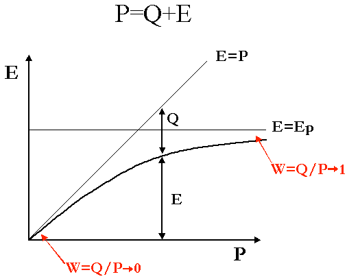
Runoff, Q, is the residual between input precipitation, P, and evapotranspiration, E. For humid climates where P is large relative to potential evapotranspiration, Ep, the runoff ratio, W, is large and can in the limit approach 1. For arid climates where P is small relative to the potential evapotranspiration, Ep, the runoff ratio, W, is small and approaches 0.
The interplay between climate, soil and vegetation is illustrated in this figure showing which runoff mechanism tends to be dominant in different physical settings.
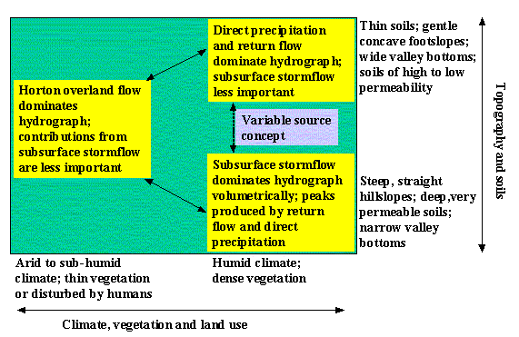
Runoff processes in relation to their major controls. (From Dunne and Leopold, 1978)
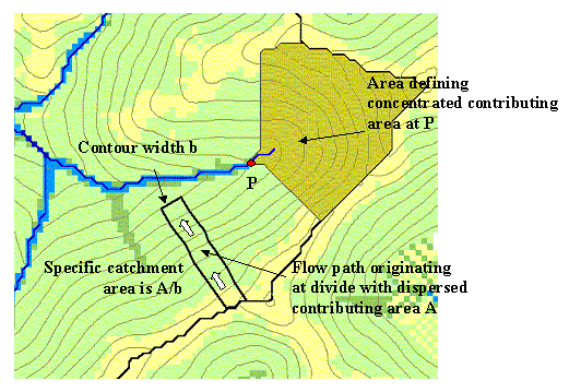
Topographic definition of contributing area, concentrated at a point or dispersed (specific catchment area) on a hillslope.
Contributing area is the most fundamental topographic property used in hydrology. In many cases runoff is expressed not in volume units, but in volume per unit area or depth units to permit comparisons between runoff from different size watersheds. Specific catchment area is the contributing area per unit contour width and defines contributing area where dispersed flow occurs as on a smooth hillslope. The topographic wetness index is defined as specific catchment area, a, divided by slope, S, or the logarithm, ln(a/S). The hydrologic model TOPMODEL which is discussed later uses the wetness index to model the variable source area responsible for saturation excess runoff. The topographic wetness index may be calculated from digital elevation model data, such as from the National Map, using GIS software, such as TauDEM.