
The Institute for Natural Systems Engineering (INSE)
Researchers and the Institute for Natural Systems Engineering (INSE) develop, test, and apply a wide range of multidisciplinary assessment tools for use in water resource systems and environmental impact assessment frameworks. These include basic life history of aquatic species; 2- and 3-dimensional hydraulic modeling; spatial sampling strategies for river corridors using remote sensing, GPS, and hydroacoustics; and advanced physical habitat modeling, including multi-agent based modeling approaches.
Key Research Areas
- Using image processing techniques to characterize riparian and aquatic habitats in rivers
- Applying aerial photogrammetry and bottom profiling techniques to develop high-resolution three-dimensional channel topographies
- Applying accepted methods and advanced techniques to relate fish population information to habitat availability and use
- Examining migration patterns, life history characteristics, and use
Featured Project
Investigating Hydraulic and Thermal Characteristics in and around Complex Habitat Structures in the Lower San Rafael River, South Central Utah
Study Area:
San Rafael River, UT
(Emery County)
Principle Investigators:
Ian Gowing
(ian.gowing@usu.edu)
Co-Researchers
Daniel Keller (Utah Division of Wildlife Resources)
Brian Laub, (Utah State University-Natural Resources)
Justin Jimenez, (US Bureau of Land Management)

Electro-fish survey on the San Rafael River, Utah, 2016.
Project Description
The San Rafael River is recognized as being in a severely degraded state and on the 303D list of degraded waters in the State of Utah. With the implementation of this River restoration scheme, we anticipate restoring the river to a more ecologically acceptable state, providing more comprehensive complex habitat to the native fish, encouraging change in channel morphology through removal of Tamarisk, planting more native riparian species along the river corridor, and removal of man-made barriers to enhance and encourage fish movement/passage througout the entire drainage.
The purpose of this work is to investigate Beaver Dam Assist Structures (BDAs) in terms of providing good quality fish habitat for native fish populations throughout the San Rafael River.
Fish habitat within the lower San Rafael is known to be severely depeleted/limited, and these BDA structures could potentially enhance native fish abundance by providing more high quality habitat. Previous research (fish-surveys) conducted by the Division of Wildlife Resources have related these structures with high fish abundance levels when compared to other habitat types within the San Rafael.
This study aims to examine what makes these structures preferred and/or more suitable habitat locations with respect to temperature and hydraulic variables including depth, mean column velocity and stustrate/cover. These variables will be investigated and analyzed during fish surveys conducted by the Divition of Wildlife Resources.

GPS work after electro-fish survey,
San Rafael River 2016

Measuring the ground water table depth within a BDA section of the San Rafael River during a high flow event

Temperature tid-bits measuring instream temperature in and around a BDA structure on the San Rafael River
Remote Sensing Collaboration with AggieAir
Evaluating river systems is an integral research component at the Institute for Natural Systems Engineering (INSE), both in terms of river ecology and channel change. Understanding the behavior of many river systems and monitoring change over time has historically required field crews to hike and map river systems on a regular basis, a feat that is costly in terms of both dollars and time.
AggieAir is a low-cost autonomous remote sensing platform developed at the Utah Water Research Laboratory that can be used to obtain high-resolution, multispectral aerial imagery that can assist the INSE group to delineate instream vegetation and substrate within river systems and monitor river corridor restoration, fish telemetry, and habitat use for applications in hydraulic modeling. The INSE collaborates with the AggieAir for these types of applications


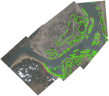
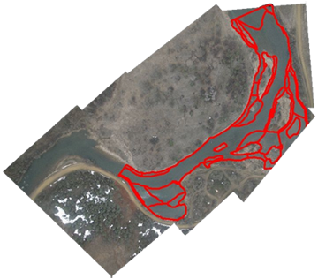
AggieAir imagery used to map channel change on the San Rafael River after recent high flow events (2011) and to assist in mapping and evaluating Tamarisk removal along the San Rafael river corridor (left) and to delineate instream vegetation (middle) and substrate (right) polygons for hydraulic modeling in a river system.
Past Projects
Gowing, I. (2017)Investigating hydraulic and thermal characteristics in and around complex habitat structures in the lower San Rafael River, South Central Utah. Project for the Utah Division of Wildlife Resources.
Gowing, I., S. Bassett (2016) Gain-Loss Study on the Lower San Rafael River. (Critical summer months and periods of low flow). Project for the Emery County Water Conservancy District, Castle Dale, Utah.
Gowing, I., C. Thomas, K. Kumarasamy, O. Diamond (2014). Minimum Flow Requirements for the San Rafael River. Project for the Emery Water Conservancy District, Castle Dale, Utah.
Gowing, I., C. Thomas, K. Kumarasamy (2013). Establishing Stage vs. Discharge relationship at multiple locations on Boulder Creek, Boulder Mountain, Utah. Project for Garkane Energy, Kanab/Loa, Utah.
Gowing, I. and C. Thomas, 2012. Gain-Loss Study on the Lower San Rafael River, South-Central Utah. Project report for the Emery Water Conservancy District, Castle Dale, Utah.
Williams, C. (2012) Boulder Creek fish population changes following increased discharge rates
Williams, C. and T.B. Hardy, 2011. Trout Population Monitoring in Boulder Creek: 2011 Results. Monitoring project report for Garkane Energy, Kanab/Loa, Utah.
Williams, C. and T.B. Hardy, 2010. Trout Population Monitoring in Boulder Creek: 2010 Results. Monitoring project report for Garkane Energy, Kanab/Loa, Utah.
Hardy, T.B., Williams, C. and C. Thomas, 2009. Trout Population Monitoring in Boulder Creek: 2009 Results. Monitoring project report for Garkane Energy, Kanab/Loa, Utah.
Hardy, T.B.; N. Bouwes; C. Williams C. Thomas, 2008. Trout Population Monitoring in Boulder Creek: 2008 Results. Ongoing monitoring project report for Garkane Energy, Kanab/Loa, Utah.
Coombs, M. and T.B. Hardy, 2007. Fish Community Structure and Habitat in the Lower and Middle Sevier River Basin. Final report submitted to the Consolidated Sevier Bridge Reservoir Company Delta, Utah and the Bureau of Reclamation, Upper Colorado Regional Office, Salt Lake City, Utah.
Hardy, T.B., et al. 2006. Validation of chinook fry behavior based escape cover modeling in the lower Klamath River. International Journal of River Basin Management. Vol. 4, Issue 3.
Hardy, T. B., C. Addley, E. Saraeva. 2006. Evaluation of Instream Flow Needs in the Lower Klamath River. Phase II final report for the U.S. Department of the Interior.
Hardy, T.B., J. Blumberg, M. Combes, L. Kent. 2006. The Rapid Assessment Tool - Methodology and Software User Manual. Final report for the Centre for Ecology and Hydrology, United Kingdom.
Hardy, T.B. 2005. Klamath Basin Water Resources Issues: Perspectives from the center of the event horizon. The Water Report. 11:9-12, 16-17.
Addley, R.C., M.Combes and T.B. Hardy. 2005.Woundfin temperature and growth investigation. Institute of Natural Systems Engineering, Utah State University, Utah Water Research Laboratory, Logan Utah.
Addley, R.C., B. Neilson, L. Basdekas and T. Hardy. 2005. Virgin River temperature model validation, Project VI.03.03. Institute of Natuaral Systems Engineering, Utah State University, Utah Water Research Laboratory, Logan Utah.
Addley, R.C., T.B. Hardy, B. Bradford, J. Ludlow, J. Thompson, and M. Combes. 2005. Santa Clara River Baseline Report. Final report for the Virgin River Resource Management and Recovery Program. Institute for Natural Systems Engineering, Utah Water Research Lab, Utah State University, Logan , Utah 84321.
Booker, D.J., et al. 2005. Rapid Assessment of the Physical Habitat Sensitivity to Abstraction. Interim Technical Report. Report to the Environment Agency and the Centre for Ecology and Hydrology. CEH Wallingford pp109.
Stevens, D.K. and T.B. Hardy, 2005. Linking operational hydrology and water quality modeling in the Weber basin: A decision support system. Presented at GSA Annual Meeting and Exposition in Salt Lake City, UT. October 16, 2005 (invited).
Gardberg, J., R.C. Addley, S. Clemens, T.B. Hardy and M. Winkelaar. 2004. Temperature and Synoptic Flow Monitoring of the Virgin River Watershed. Institute for Natural Systems Engineering, Utah Water Research Lab, Utah State University, Logan, UT 84322-8200.
Hardy, T.B., et al. 2004. Benefits evaluation of channel reconstruction on lower LaVerkin Creek using two-dimensional hydrodynamics and biological habitat modeling. Final report prepared for the Washington County Water Conservancy District. Institute for Natural Systems Engineering, Utah Water Research Laboratory, Utah State University, Logan, UT 84322-8200.
Combes, M. and T. Hardy. 2004. Fish Community Structure and Habitat in the Lower and Middle Sevier River Basin 1999-2003. Final Report for the Consolidated Sevier Bridge Reservoir Company, Delta, UT and the Utah Division of Wildlife Resources. Institute for Natural Systems Engineering, Utah Water Research Laboratory, Utah State University, Logan, UT 84322-8200.
Shoemaker, J. and T.B. Hardy. 2004. Development and Application of an Instream Flow Assessment Framework for the Fountain Darter (Etheostoma fonticola) and Texas Wild-Rice ( Zizania texana ) in Spring Lake and the San Marcos River System. Institute for Natural Systems Engineering, Utah Water Research Laboratory, Utah State University, Logan, Utah 84322.
Hardy, T.B. and C. Addley. 2003. Instream Flow Assessment Modelling: Combining Physical and Behavioural-Based Approaches. Canadian Water Resources Journal. 28(2):1-10.
Hardy, T.B., C. Addley, J. Deacon, C. Williams. 2003. An Assessment of Potential Limiting Factors of Native Fish Species in the Virgin River between Pah Tempe and the Washington Fields Diversion. Draft report prepared for Virgin River Resource Management and Recovery Program. Institute for Natural Systems Engineering, Utah Water Research Laboratory, Utah State University, Logan, UT 84322-8200.
Thompson, J. and T.B. Hardy. 2003. An Instream and Riparian Habitat Assessment of the Santa Clara River Watershed. Draft report prepared for the Washington County Water Conservancy District. Institute for Natural Systems Engineering, Utah Water Research Laboratory, Utah State University, Logan, UT 84322-8200.
Basdekas, P., T.B. Hardy, and H. Milliken. 2003. Precision and Accuracy of One-Dimensional Hydraulic Modeling (R2-Cross) and Implications for Establishing Fisheries Base Flows. Prepared for US Department of Agriculture, US Forest Service. Institute for Natural Systems Engineering, Utah State University.
Hardy, T.B. 2003. Seepage Run Study below the Quail Creek Diversion. Prepared for The Washington County Water Conservancy District. Institute for Natural Systems Engineering, Utah Water Research Laboratory, Utah State University, Logan, Utah 84322-8200.
Hardy, T.B., K. Hall, D. Jeon, J. Magrath, and M. Anderson. 2003. Quail Creek Pipeline Gravity Based Return Flow System Report: Feasibility Design to Achieve Summer Temperature Mitigation within the Main Stem Virgin River above Quail Creek for Native Fish. Prepared for The Virgin River Resource Management and Recovery Program. Institute for Natural Systems Engineering, Utah Water Research Laboratory, Utah State University, Logan, Utah 84322.
Shoemaker, J., T.B. Hardy. 2003. Bathymetry of the River/Sevier Bridge Reservoir. Prepared for Bowen, Collins, & Associates. Institute for Natural Systems Engineering, Utah Water Research Laboratory, Utah State University, Logan, Utah 84322-8200.