Projects
A brief summary of research efforts within the Logan River Observatory.
Characterizing karst mountain watersheds through streamflow response to snowmelt
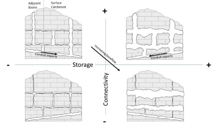
Time series analysis of LRO station continuous discharge, specific conductance measurements, and gridded snowmelt predictions from Tyson et al. (2023) were used to characterize seasonal hydrology and evaluate dominant watershed controls for Logan River subcatchments and springs. Unlike many snowmelt-dominated western watersheds, the hydrologic variability between sites was not well described by typical watershed properties, including elevation or surficial geology.
Outcome: A new conceptual framework of karst mountain watershed hydrology to characterize subsurface controls on streamflow dynamics and climate sensitivity based on readily measured hydrologic and climate variables was developed. This conceptual framework improves understanding of complex hydrogeology in the Logan River to guide water managers in estimating future water supply changes.
Thurber, Daniel Meade (2022). "Characterizing Karst Mountain Watersheds Through Streamflow Response to Snowmelt," Master’s Thesis, Utah State University, https://doi.org/10.26076/3fb9-d6ee
Precipitation changes in snowmelt dominated watersheds with karst geology
Neilson et al. (2018) found that significant amounts of river water were repeatedly exchanged between the river and the local aquifer and that the majority of groundwater entering the river moves quickly through the watershed via karst aquifer conduits. These findings suggest that river flow each summer is highly dependent on very recent aquifer recharge from snow accumulation during the prior winter. Future research will focus on quantifying how changes to snowpack will influence summer streamflow.
Xu, T., Q. Longyang**, C. Tyson**, R. Zeng, B.T. Neilson (2022). Hybrid Physically Based and Deep Learning Modeling of a Snow Dominated, Mountainous, Karst Watershed, Water Resources Research, 58 (e2021WR030993), https://doi.org/10.1029/2021WR030993
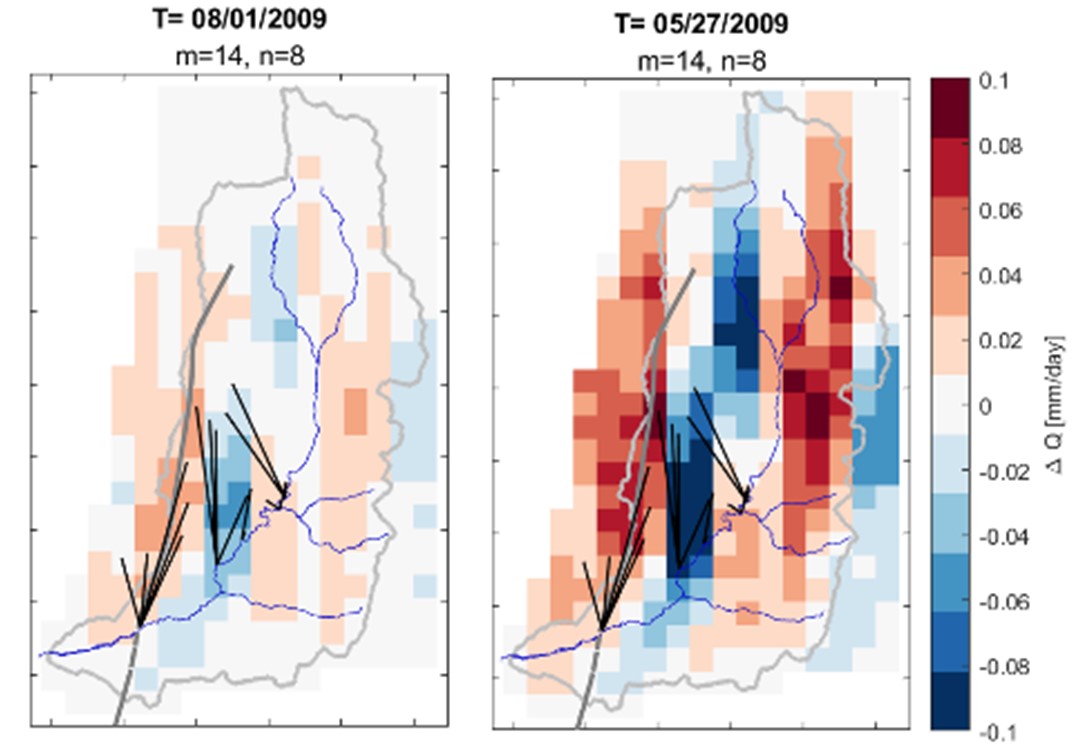
Effects of meteorological forcing uncertainty on high-resolution snow modeling and streamflow prediction in the Logan River watershed
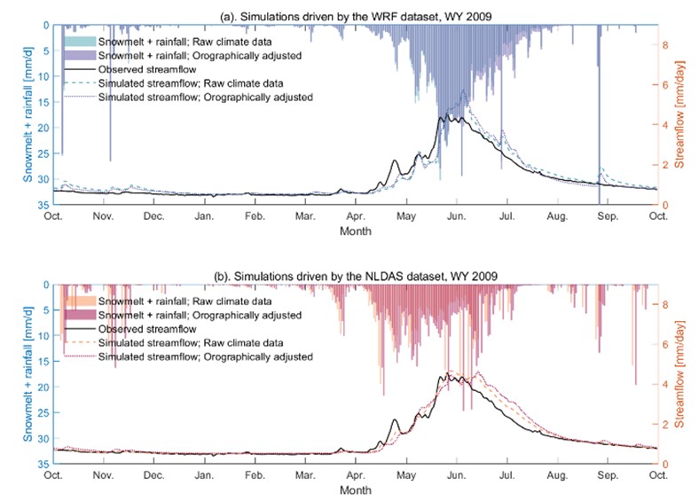
Accurately simulating streamflow in snow dominated mountainous karst watersheds, including the Logan River watershed, relies on high-quality meteorological forcing at resolutions adequately fine to capture spatial variability controlled by complex terrain. To investigate the impacts of meteorological uncertainty on streamflow simulation, we drove the hybrid process-based and deep learning models developed in Xu et al. (2022) using two meteorological datasets, both at their original resolutions, and downscaled to 100 m based on topographic adjustments.
Outcome: A detailed understanding of meteorological uncertainty on streamflow simulation specifically for snow dominated mountainous karst watersheds. Results suggest the value of dynamically downscaled meteorological datasets, as well as orographically adjusting coarse-resolution datasets, when the former is unavailable. In addition, ensemble analyses using multiple meteorological datasets improve streamflow prediction accuracy.
Tyson**, C., Q. Longyang**, B.T. Neilson, R. Zeng, T. Xu (In press). Effects of Meteorological Forcing Uncertainty on High-Resolution Snow Modeling and Streamflow Prediction in a Mountainous Karst Watershed, To appear in Journal of Hydrology
Beaver pond geomorphology influences on pond nitrogen retention and denitrification
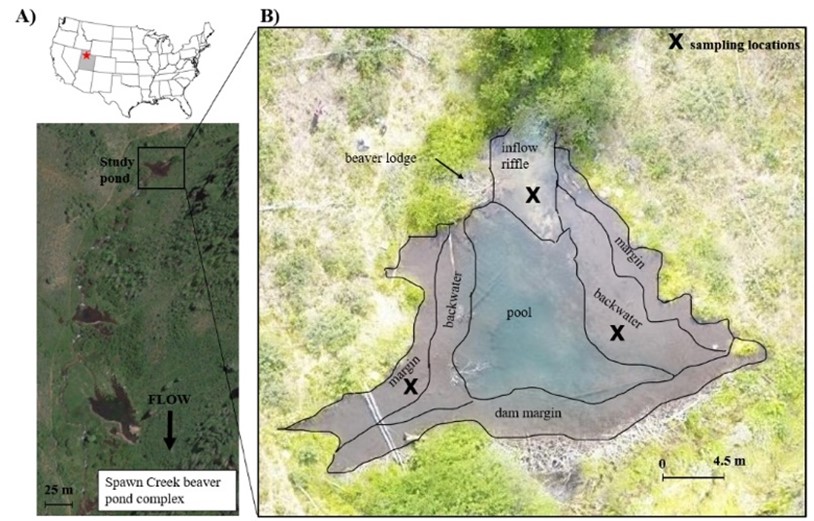
Beaver ponds dot the headwaters and tributaries of the Logan River watershed. Beaver ponds are composed of distinct geomorphic units (e.g., backwater, margin, riffle). Murray et al. (2023) explored whether nitrogen (N) transformations, such as sedimentation or denitrification, will covary with a pond’s geomorphic unit classification. To test this hypothesis, the physical structure of one pond was catalogued using geomorphic unit criteria. We conducted experiments within three geomorphic units to quantify various N cycle steps from sedimentation to denitrification and also measured sediment characteristics related to N cycling such as organic matter concentration and C and N isotope composition.
Outcome: Backwater areas were found to facilitate the storage of sediment N and, importantly, denitrification. The inflow riffle facilitated N transport rather than transformation, while nitrification rates were highest in the margin. It was concluded that the geomorphic composition of a beaver pond can inform whether beaver activity can provision water quality remediation.
Murray**, D., B.T. Neilson, J. Brahney (In press). Beaver pond geomorphology influences pond nitrogen retention and denitrification, To appear in Journal of Geophysical Research - Biogeosciences
Toward automating post processing of aquatic sensor data
The data collection sites in the LRO generate large volumes of time-series data from in situ hydrology, water quality, and climate sensors. These data contain anomalies—e.g., issues with the data resulting from sensor malfunctions, adverse environmental conditions like ice buildup around sensors, etc. Anomalies must be detected and removed prior to the data being used for important analyses. The removal process is called “quality control” and usually involves a technician visually examining data and applying corrections where needed. However, given the volume of data produced in the LRO, the quality control process is labor intensive and difficult to maintain. In this work, PhD student Amber Jones led an investigation of how data streams from environmental sensors can be automatically processed to detect and correct anomalies.
Outcome: A software program called PyHydroQC aimed at automating the quality control process and reducing the time required to produce high quality data records.
Jones**, A. S., T.L. Jones, J.S. Horsburgh (2022). Toward automating post processing of aquatic sensor data, Environmental Modelling & Software, 151(105364), https://doi.org/10.1016/j.envsoft.2022.105364
Comparing 1D, 2D, and 3D hydraulic models In Logan River flooding applications
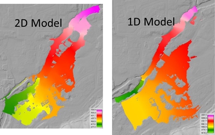
Kesler (2023) found a 1D HEC-RAS model to be not ideal for understanding flooding around the Crockett Canal diversion structure along the Logan River. Lateral flow extent for a 2500 cfs flood was not captured well in the 1D model. The 2D model, consistent with the 3D model, showed water leaving the Logan River channel far enough upstream of the diversion structure that there was no indication of the diversion structure causing the flooding. Hydraulic grade lines and water surface elevations do not show significant water accumulating behind the diversion structure.
Outcome: More advanced 3D hydraulic modeling provides insights regarding flow patterns above the Crockett Diversion structure; however, 2D HEC-RAS modeling provided similar insights regarding the extent of flooding and can provide more reliable results than 1D modeling approaches.
Kesler, Taylor (2023). “Comparing 1D, 2D, and 3D Hydraulic Models in Urban Flooding Applications,” All Graduate Theses and Dissertations, 8691, https://doi.org/10.26076/38b6-8acb
Logan River Observatory support of local canal companies
Drought conditions throughout the western US have prompted significant interest in ensuring that the water distribution throughout rivers and canal systems is well understood. The LRO worked with multiple canal companies in summer 2021 and 2022 to:
- Determine flow measurement accuracy at various Utah Division of Water Rights gaging locations,
- Estimate flows in ungaged diversions, and
- Estimate flow gains and losses in various portions of the river and canal system.
Outcome: Michael Lasswell, PhD student, and B. Neilson are working to help understand the environmental impact of proposed diversions and canal system changes along the Logan River below the Utah Water Research Laboratory. Similarly, Lasswell and Neilson are working with the Cache Water District to initiate a more holistic project on the Blacksmith Fork an
d adjacent drainages to determine the optimal approaches for water management based in part on detailed seepage studies completed on a series of canals and the Blacksmith Fork River in summer 2022.
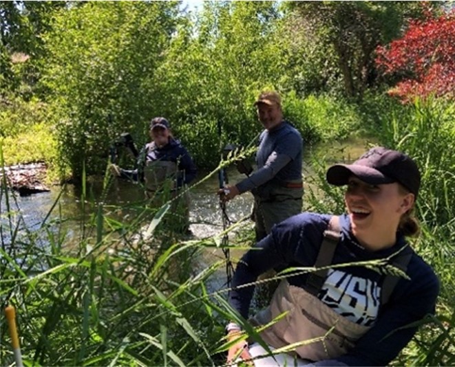
Logan River LiDAR
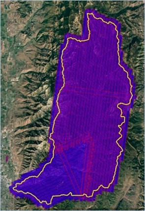
Light Detection and Ranging (LiDAR) topography data (0.5-m resolution) was collected over the entire canyon portion of the Logan River watershed in Fall 2020. This data collection was a collaborative effort between Logan City, the LRO, and USGS 104(b). The LiDAR data augments data already available for the valley section of the Logan River and has provided coverage of the full watershed to facilitate ongoing and future hydrologic studies.
Outcome: These data are foundational to various on-going or planned research activities. For example, two different PhD students are working to establish new methods for mapping sinkholes (or groundwater recharge locations) based on this detailed dataset. Additionally, these data have been used to attract recent NSF funding (see Phillips 2022 NSF Grant), used in various conference presentations, and were instrumental in Benitez (2023) MS thesis.
Snow LiDAR
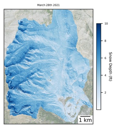
Snow-on LiDAR data were collected during March 2021 in the Franklin Basin portion of the watershed. The resulting data have been combined with LRO snow-off LiDAR and Citizen Scientist snow data through machine learning to model snowpack at high spatial and temporal resolutions at low cost. Particularly focusing on basin-scale estimation of snowpack in heterogeneous terrain and regions otherwise underrepresented by high-resolution snow products, this work supports our understanding of snow distribution and water availability in critical watersheds.
Outcome: These data are being used to determine future options for using crowdsourced data to understand water availability via more accurate representation of snow distribution.
Murray**, D., B.T. Neilson, J. Brahney (In press). Beaver pond geomorphology influences pond nitrogen retention and denitrification, To appear in Journal of Geophysical Research - Biogeosciences
A hydraulic routing and river temperature model of the valley portion of the Logan River
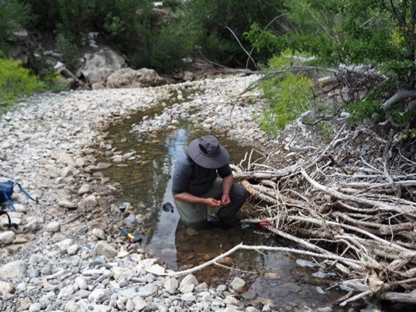
Buahin et al. (2019) (see Appendix C), developed and calibrated a temperature model for a large section of the lower Logan River. The model provided estimates of lateral inflow volumes and temperatures which were used to indicate whether lateral inflows originated from colder groundwater or warmer urban/agricultural runoff. This modeling framework will be used to assist in assessing the environmental impacts associated with proposed changes to the Crockett Diversion and diversions from the Logan River (see above).
Outcome: This analysis resulted in improved understanding of the dynamic inflows and outflows to the river system. The model will be used in various projects to assess the impacts of different instream flow management options on river temperature and fisheries.
Lateral inflow sources in the valley portion of the Logan River
Building on Buahin et al. (2019), Tennant et al. (2021) used detailed measurements and flow and mass balances to further investigate where gaining and losing conditions occur, when they occur, the source of the flow (urban versus agricultural areas), and whether it joined the river via surface or subsurface flow.
Outcome: Similar to above, these findings will help guide decision making by assessing the impact of different water distribution scenarios on lateral inflows to Logan River that will change as canals are lined/pressurized or stormwater practices are altered.
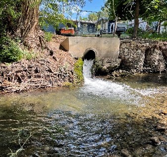
Logan River Observatory as part of a network of worldwide research and observatory catchments
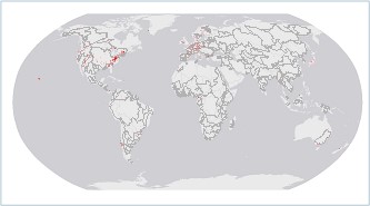
The Logan River Observatory was included in a Special Issue of the Hydrological Processes journal titled “Research and Observatory Catchments: the Legacy and the Future” (Hydrological Processes: Vol 35, No 5 (wiley.com)). To further promote the contributions of the LRO to the broader research community, a presentation was given at the Research and Observatory Catchments: The Legacy and the Future Seminar Series. The map shows the worldwide network of observatories involved.
Outcome: Neilson et al. (2021) highlighted the LRO as one of the only karst observatory watersheds that has detailed subwatershed flow measurements. This article highlights the importance of flow data in understanding watershed hydrologic responses and the role in future water planning. The State of Utah’s investment in long term hydrologic monitoring was discussed and was highlighted as a unique attribute of the LRO. Tennant et al. (2021) also provided additional analyses and further illustrated the utility in the detailed flow measurements that the LRO network provides. These data and results are being used in on-going water management decisions.
Current Projects
- Groundwater Assessment of Cache Valley: An updated evaluation of groundwater recharge, yield, and vulnerability in Cache Valley, E. Humphrey, T. Marston (Utah USGS Water Science Center), B. Neilson, D. Newell (USU), K. Solomon (University of Utah), Utah Division of Water Rights/Cache Water District/Cache County, 2024-2027.
- Linking long-term data from the Logan River Observatory to changes in snowpack to inform local water management and conservation planning, S. Hotaling, B.T. Neilson, K. Becker, USU Extension Water Initiative Grants Program, 2024-2026.
- Monitoring and Quantification of Great Salt Lake Inflows from the Bear River, B.T. Neilson, B. Crookston US Fish and Wildlife Service via GSL-WET, 2024-2025.
- Preliminary Data Collection to Support the Groundwater Assessment of Cache Valley, B.T. Neilson, Utah Division of Water Rights, 2023-2024.
- Hydrochemical Tracer Sampling in Logan River to Inform Future Water Availability, B.T. Neilson, USU Extension Water Initiative Grants Program, 2022-2024.
- CIROH: Advancing Snow Observation Systems to Improve Operational Streamflow Prediction Capabilities, C.A. Oroza, R. Johnson, D. Taylor, C. Skalka, J. Horsburgh, National Oceanic and Atmospheric Administration (NOAA), 2023–2026.
- Advancing Camera-Based Monitoring for Operational Hydrologic Applications, S. Young, J.S. Horsburgh, E. Goharian, United States Geological Survey, 2023–2026.
- Cooperative Institute for Research to Operations in Hydrology (CIROH): Modernized Standards and Tools for Sharing and Integrating Real time Hydrologic Observations Data, J.S. Horsburgh, National Oceanic and Atmospheric Administration (NOAA), 2022–2025
- Collaborative Research: Separating the climate and weather of river channels: Characterizing dynamics of coarse-grained river channel response to perturbations across scales, C.B. Phillips, National Science Foundation, 2022–2025
- Collaborative Research: Quantifying Watershed Dynamics in Snow-Dominated Mountainous Karst Watersheds Using Hybrid Physically Based and Deep Learning Models, B.T. Neilson and D.L. Newell, National Science Foundation, 2021–2024
- Monitoring and Research for Water Quality and Stormwater Management in Logan City, UT, B.T. Neilson and J.S. Horsburgh, Logan City, 2018–2023
- Determining the mobility, fate, and ecological consequences of dust-derived constituents in mountain watersheds, J. Brahney, National Science Foundation, 2020–2025
- Quantifying microplastic and nanoplastic deposition in the Bear River Mountains, J. Brahney, United States Department of Agriculture, 2021–2024
Past Projects
- Hydrochemical Tracer Sampling in Logan River to Inform Future Water Availability, B.T. Neilson, D.L. Newell, E. Rivers, P. Brooks, USU Extension Water Initiative Grants Program, 2022–2023
- Microplastic transport to the Great Salt Lake through the Logan and Bear River system, J. Brahney, P. Budy, B.T. Neilson, State of Utah Division of Forestry, Fire, and State Lands, 2021–2022
- Assessing the Sources, Transport, and Fate of Microplastic in the Logan River Watershed, K. Moor, J. Brahney, B.T. Neilson, United States Geological Survey 104(b)/UWRL, 2021–2022
- Leveraging LIDAR and Citizen-Science for Low-Cost, High-Resolution Snow-Depth Estimation, Carlos A. Oroza, USGS 104(b), 2020-2021
- Improving the Hydraulics of Urban Flooding, Z.B. Sharp, USGS 104(b), 2020–2022
- Monitoring and Research for Water Quality and Stormwater Management in Logan City, UT, B.T. Neilson and J.S. Horsburgh, Logan City, 2018–2021
- Mapping Didymosphenia in the Logan River Drainage, (USGS 104(b)/UWRL), Brahney and B.T. Neilson
- Obtaining Lidar Data to Support Research in the Logan River Watershed, B.T. Neilson, 2020UT304B Utah Water Research Laboratory and USU Civil and Environmental Engineering Department, 2020–2021

