The AggieAir UAS Service Center maintains a collection of state-of-the-art uncrewed aerial vehicles, payloads, and other scientific equipment for data collection. Custom sensors can be adapted to either platform for all your data requirement needs. Through joint collaboration and discussions we can decide the best available equipment to use for your research project, and we will do the rest.
UAS Platforms
PRISM Lite
NDAA Compliant
VTOL
PRISM Lite is the newest addition to the AggieAir Service Center fleet. This high-performance drone is NDAA Compliant, and is secure to use for government grants and projects. The PRIMSE Lite has been developed around an open ecosystem, allowing the integration of all of our different payloads, sensors, and peripheral devices.
- Camera configuration includes any of the current MicaSense sensors available (Altum-PT, Altum, Dual band).
- Flight Ceiling 3,000 m / 10,000 ft MSL
- 24 Mile Line of Sight Range (dependent on factors such as atennas, RF noise, etc)
- Cruise Speed: 25-30 mph
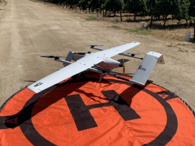
Great Blue
Hybrid VTOL/Fixed Wing
GreatBlue is built for long-range flights with the ability to cover much larger areas. GreatBlue utilizes vertical flights for both take-off and landing instead of traditional run-way takeoffs, allowing it to be deployed virtually anywhere. It's large size allows Great Blue to carry multiple payloads at once.
- Camera configuration includes any of the current MicaSense sensors available (Altum-PT, Altum, Dual band).
- Flight Ceiling 10,000 ft MSL
- Single-Flight Max at 2500 ft AGL & 16,000 Acres
- Linear Range: 120+ miles
- Cruise Speed: 50 mph
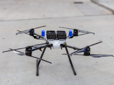
DJI Matrice 300
VTOL
The DJI Matrice is the latest in commercial drone platforms, allowing our crew to be up in the air in minutes. Vertical take-off and landing, 55 minutes of flight time, and advance AI capabilities mean we can capture multiple flights to get the most accurate data.
- Camera configuration includes any of the current MicaSense sensors available (Altum-PT, Altum, Dual band).
- 55 Minutes of Flight Time
- Single-Flight Max at 2500 ft AGL
- 6 Directional Sensing & Positioning
Payload Options
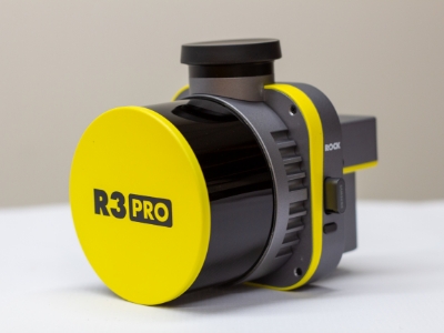
ROCK R3 Pro LiDAR
3D LiDAR & Photogrammetry Data
- Captures 1.28 million points per second
- 26MP high-resolution detatchable camera
- Survey-Grade (± 3 cm accuracy)
- Triple-band GNSS receiver
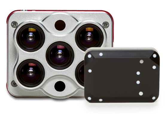
MicaSense Altum - PT
Multispectral Sensor
- Thermal sensor - resolution 33cm per pixel at 120m flight elevation
- 5 Band Multi-spectral camera (Blue, Green, Red, Red-edge, Near-IR)
- High resolution 12.4 MP Panchromatic sensor for super sharp images

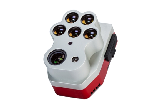
MicaSense RedEdge MX DUAL Sensor
Dual-Camera System
This dual camera system, produced by MicaSense, uses 10 spectral bands to enable direct comparison between satellite and drone data.
- 10 spectral bands from 400nm to 10000nm (blue to infrared).
- 8cm pixel resolution per band at flight elevation of 120m.
- Radiometrically calibrated spectral bands for repeatable measurements.
- Ability to compare imagery directly with LandSat and Sentinel satellite data.
- Imagery allows for monitoring of shallow water environments with coastal spectral band.
- Ideal for vegetation task classification.
MicaSense Altum
Camera System
This advanced camera, produced by MicaSense, integrates a radiometric thermal camera with five high resolution narrow bands, (Red, Green, Blue, red edge and near-IR).
Resolution:
3.2 MP : 81 CM
Spectral Bands:
Blue, Green, Red, Red Edge, Near Infrared
COAs
The AggieAir Service Center has a large collection of COAs, certificate of authorizations, which are issued by the FAA and allow our UAVs to fly in areas and heights in otherwise restricted areas.
AggieAir also holds a state-wide COAs in Utah and California that allows the team to fly in Class G airspace anywhere up to 1,119 feet that is not in restricted airspace. Other COAs include:
- Great Salt Lake South FAA Form 7711-1 2023-WSA-13496
- California FAA Form 7711-1 2023-WSA-13868
- FAA Form 7711-1 2023-WSA-13621_StateOfUtah. 1
- FAA Form 7711-1 2023-WSA-12538 Vineyard Rev2
- FAA Form 7711-1 2023-WSA-13203_Signed_CheeryOrchard
- FAA Form 7711-1 2023-WSA-12889 Great Salt Lake. 1
- FAA Form 7711-1 2023-WSA-11887 PatrickBrown Rev1. 1
- FAA Form 7711-1 2023-WSA-12076 Olam Ranch Rev2
- FAA Form 7711-1 2023-WSA-11875 Rev1_TravisAFB
- FAA Form 7711-1 2023-WSA-12075_CacheValley
Propeller Aeropoints

Aerial Targets
Propeller Aeropoints are smart ground control targets with built in GNSS that makes accurate remote sensing data both extremely easy and quick to capture. With over 40 aeropoints, the AggieAir team can cover up to 720 acres.
Scientific Equipment
Various equipment can be used to customize every mission's agenda. Below are a few of the options available.
Portable Davis Vantage Pro Weather Station
This portable weather station can be located on-site & contains a suite of sensors including an anemoeter, rain collector, temperature, humidity, and solar irradiance sensor.
Air Quality Sensors
This sensor is used to measure ozone levels.
Total Station
An electronic instrument used for surveying, reading slope distances and performing advanced coordinate calculations.
Leaf Area Index Sensor
Sensor used to describe the state and progress of crop canopies.
Portable Soil Moisture Sensor
Portable sensor to measure soil moisture content.
Mounted Weather Station
This weather station records humidity, atmospheric pressure, and air temperature.
RTK GPS
This system is designed to enhance the precision of position data derived from satellites.
Hyperspectral Sensor
This sensor allows us to obtain the spectrum for each pixel in the image of a scene.
Portable SPAD 502 Chlorophyll Meter
A lightweight handheld meter used to measure chlorophyll content of leaves without causing damage to plants.
Scintillometer
Sensor to measure energy fluxes and scintillation of light caused by atmospheric conditions.
Incident Light Sensor
This sensor compensates for cloud cover, haze, and
shifting solar intensity.